
價格:免費
更新日期:2019-05-12
檔案大小:13M
目前版本:7.2.00
版本需求:Android 4.2 以上版本
官方網站:http://www.atlasguides.com
Email:support@atlasguides.com
聯絡地址:2225 N Gemini Rd #E8 Flagstaff, AZ 86001

Please download "Guthook Guides: Hike & Bike Offline" to access the Long Trail Trail guide. Existing customers may transfer their purchases to the Guthook Guides: Hike & Bike Offline app. This app is no longer supported and will be removed from the Play Store October 2019.
Guthook's Long Trail Guide is a detailed, map-based smartphone guide for your hike on the 270-mile Long Trail. It maps and lists more than 500 important hiker waypoints along the LT such as water sources, shelters, tenting sites, road crossings, resupply locations, and may others.
Key features:
- No mobile or internet connection is required after initial setup -- works in Airplane Mode
- Detailed maps with your GPS location
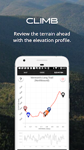
- Elevation profile view
- Custom route creator
- Multiple offline map choices
- Real-time comments from other hikers
- Send your current location to friends or family via text message or email
The guidebook lists every waypoint in order by distance along the trail and how far away you are from each waypoint. The guidebook also includes a detailed town guide for major resupply points, towns, and services along the Long Trail.

Waypoint details include:
- Mileage point and elevation
- Photographs
- Distance to the next water source and tent site
- Comments section where you may post comments and read other hikers’ comments
Types of waypoints:
- Water sources (including the reliability of each water source)
- Detailed resupply and town information:
- post offices and other package services
- restaurants
- grocery stores and convenience stores
- gear shops and hardware stores
- laundromats
- lodging, public showers, public restrooms
- public libraries
- Tenting sites/camping sites
- Trail junctions
- Parking areas along the trail
- Picnic areas, campgrounds, ranger stations
- Roads, railroad tracks, power lines, fences, gates
- Natural landmarks (e.g. mountain passes)
- Privies/restrooms

- Views
About the Long Trail*: The Long Trail, or LT, is the original and oldest long distance hiking trail in the United States. The 273-mile trail crosses south-to-north through the state of Vermont along the Green Mountains, from the Massachusetts border to the Canada border. The first 107 miles of the trail overlaps the famous Appalachian Trail. Countless hikers enjoy hiking anywhere from a few miles to the entire trail each year.
*"Long Trail" is a registered trademark of the Green Mountain Club
